Sorry I've been missing... I don't intend to go 3 weeks between blog posts, just a lot less inspired these days than I used to... Always intend to do better - I've got 3 or 4 I WANT to write, just seems something more important comes up, even if it is sitting watching a movie on TV!
I've been at "Ketelsen East" for weeks now, and the trip up was quite spectacular! Perfect weather for the first half of the trip, and I took nearly 200 frames on the flight. Of course, a lot of those were for stereo pairs, so sometimes took 2 or 3 as we flew along for a good baseline for clouds or features on the ground.


The flight was delayed - the plane came
in late. The Chicago noon flight originates there in Illinois, then returns on the flight I take. Once we took off (about 20 minutes late) I could tell the pilot was intending to make up time as he turned northeast immediately! Usually we take off towards the SE and sometimes go 80 miles or more before heading towards the NE, but even shortly after takeoff we flew over the "Boneyard" of the Davis Monthan Air Force Base. The Aerospace Maintenance and Regeneration Group (AMARG) stores over 4,000 planes for long-term storage for possible return to service or for use in parts for planes in use. At left is one view of part of the storage facility, and at right, a second frame is added from a couple seconds later to make an anaglyph stereo pair (red/blue glasses needed to see the 3D!). For reference, I've never flown over it before - my first indication that we had started our northward journey early!


I usually book the left-side window so that I'm not looking or shooting into the sun. That means going towards Chicago Mount Graham and the LBT telescope are some distance out my window. We've been as far as south of Willcox, so it can be as far as 20 miles or more away. I was suspicious when I couldn't spot it and suddenly it appeared almost straight down below me! I could barely catch it without the observatory partially blocked by my window frame! Shown at left is a wide shot of the 3 telescopes atop the mountain. The mountain road up from near Safford (east side of the mountain) winds west past the Observatory, then snakes up the slope from the west as shown here. Then at right is shown the stereo anaglyph that reveals the telescopes "popping out" from the peak, and the local terrain as well as the winding road climbing the hill.


Shown here is a close-up of the Mount Graham International Observatory (MGIO) which consists of the Large Binocular Telescope (LBT) in the large rectangular structure, the Vatican Advanced Technology Telescope (VATT) at left, and the Sub-Millimeter Radio Telescope (SMT) between them. Interestingly, I did a substantial amount of work on all three of the telescopes! Also recently in the news, the SMT was recently one of the telescopes that added data to image the black hole in the galaxy Messier 87! And of course, another 3D image as above, starting to show some of the topography of the east side of the mountain as well...
I think this is about the first time I've been able to get a good look at the mountaintop since
the big fires there a couple years ago. It looks to have pretty much decimated the stands of trees atop Graham other than the well-defended area around the observatory. Go to the link to see the amazing footage of a DC-10 dropping retardant on the fire which all but saved the Observatory!


Another 30 miles past the Observatory is another feature usually seen some distance away - the largest open-pit copper mine in the western hemisphere - 740 million pounds was refined in 2017, and employed over 3,000 people! This time, again we flew pretty much right over it, and a pair of frames a few seconds apart show good stereo results, as shown in the image at right...
According to references in Wikipedia, it has ore reserves of 3.2 billion tons grading at about .2%, so 500 pounds of ore must be processed to return a pound of pure copper!
From an industry paper describing the operation, it is the largest application of leaching/solvent extraction operations in the world. The leaching fields are not well shown in these images (out of frame to lower left), but the pits are shown well and give a great 3D effect in the anaglyph at right...


Shortly after the mine, I got lost... We typically pass over the VLA radio telescope array in west-central New Mexico, but I never saw it - likely off the right side of the plane. Also never seen was Albuquerque - another waypoint I usually always spot. Another indication that we were north of the usual path taken. What I did spot was some interesting terrain NE of the Morenci mine - likely in the Gila Wilderness in New Mexico. There are some striking canyons seen before there, and while these weren't exactly the same landforms, that's what I'm calling them! They make an interesting 3D view at left...
When lost, you look for something striking to try to identify from Google Maps. After not seeing Albuquerque, I spotted some contrasting dark and light landforms. A quick look online found it - the towns of Milan and Grants in north-Central New Mexico, shown at right.


A few minutes later another interesting shot - northern New Mexico, like the area around Flagstaff in northern Arizona, is full of volcanic features. We passed over a distinctive peak that otherwise defied description. I think it is Cerro Alesna. It is described as a "volcanic neck", which I believe is the remnants of a lava plug in the volcano, then the volcano eroded away, leaving the remarkable outline.
Baboquivari south of Kitt Peak where I've spend many hours gazing, is a similar form and also quite striking. The peak part here is so dark it is difficult to see details in the 3D image, but you get the idea... Straight shot at left, 3D at right...


I got lost again - easy to do in southern Colorado with the southern Rocky Mountains... Again, was looking for something striking to find on a map and once clear of the mountains, found this colorful set of catchment ponds at the south end of a city on the eastern edge of the mountains. Yes, it was Colorado Springs, and the catchment ponds (bright yellow, orange and white) are associate with the Nixon coal-fired power plant near the small town Fountain. On the upper left of the frame at left, which is the bottom of the next frame at right is the landing strip for the Butts Army Air Field serving Fort Carson in Colorado Springs, which is the metropolitan area snuggled up against the Rockies in the photo at right...


Colorado is a big, mostly featureless state - at least the eastern half. So I got lost again. I saw a huge windmill farm that seemed to go on for many miles (and minutes of flying time at 500mph!), but windmill turbines are difficult to locate on Google maps, especially if they are new and maps are not! It wasn't until another 20 minutes till I saw another positive landmark, easy to spot on the Google maps - a big reservoir! A long straight one, then followed by another a few minutes later. Couldn't find anything in Kansas (the usual route), but finally found them. At left is Swanson Lake near Trenton in southwestern Nebraska, and at right, the distinctive shape is of Red Willow Reservoir.


As can be seen in these photos, even over the few minutes between these last photos, clouds were increasing, and they became quite thick - I never saw the Missouri or Mississippi Rivers, but clouds are fun to watch too - especially in 3D!
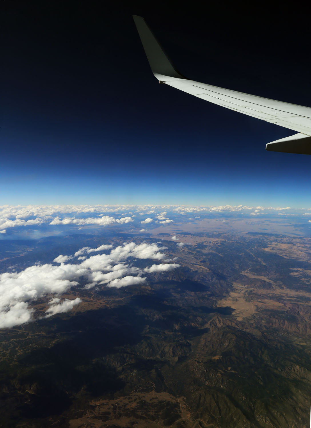
These photos were taken in southern Colorado, with the front range coming into view. At left is a single photo - one of the few showing the sky. Note how dark blue it is when flying close to 40,000 feet - not much scattering to make it the normal sky-blue we see from the ground! And while the horizon looks curved, I'm not certain I should point it out as lens distortions, especially at wide angles, can cause that too! At right is the 3D anaglyph version. I wasn't sure that the wing, obviously not displaying ANY baseline 3D, would screw up the image, but it is obvious that it does not.


Photos of clouds are oftentimes confusing, as you lose perspective when they can appear at several levels and is difficult to interpret if a piece here is in front or back of others. The 3D versions are MUCH more definitive, and works on even the messiest of photos - in stereo it is usually easy to see the shape and relative distance to the clouds. Here are a couple more interesting structures I shot once the skies clouded up over the Midwest and there was nothing else to see till we landed in a misty rain in Chicago.

So you will have to forgive my weakness for 3D images - or at least trying to capture them! Seems the anaglyph version of display is easiest for people to view (many have the required red/blue glasses. Of course, it can mess up the color balance of objects that are colored similarly to the red or blue colors of the filters needed to view the images. At least I have fun - up to YOU if you enjoy them too!

 Under the category of "what the heck is that" is this coin I received in change the other day... The front side (left) is normal, but the back is in color! I didn't think much of it, figured someone was doodling with fingernail polish, and didn't think much of it. I finally dug it out of my change jar yesterday and took a good look at the obverse side. Shown at right, it appears someone took cares to color at least part of the design - trying to stay inside the lines, anyway... I took out my "supermacro" (Canon MP-E 65mm) to document here. The upper images here are at the lowest magnification I can get - about 1:1, or life-size on the sensor. The quarter just quite does not fit in the field of view. But even here you can see that the scene isn't a straight painting, rather it appears to be a multi-layer screen print. Note the screen dots on the details of the woman and what she is carrying - indicative of some sort of a screening or printing procedure.
 The close-ups here were taken with the same lens at about 3X magnification (scale at bottom is in millimeters. Note especially on the "Pennsylvania" detail, there appears to be a slight registration error of about a half millimeter. At right you can also see the barely-visible E Pluribus Unum through the layer of color at bottom...


