Monday, December 30, 2019

Another Window Seat

Truth be told, I never PLAN to have blog posts come out only every 5 weeks - that is just the way it turns out! I still have plenty of explorations to write about, it is just that I lack inspiration and hours in the day it seems...

So am trying to get back into the habit. While generally a post with this title indicates another cross-country trip sitting beside an airplane window! Well the first part of the statement is true, but this time the trip was from the 'ole van, and pics were taken from behind the wheel. It really isn't a dangerous undertaking - these photos are split between the cell phone and my Canon 6D - easy enough to point and shoot in auto mode with a minimum of aiming, or taking eyes off the road. Anyway, I hope you enjoy the story of the trip!

The reason for the drive was 2-fold. First, I HATE trying to fly near the holidays. The trips are expensive and jam-packed, and heaven forbid if there is bad weather, it might be days to get to your destination! I dislike the cattle-car packing of the flights these days, and consider myself fortunate for an empty seat near me, but it won't happen near Thanksgiving or Christmas. The other reason for the drive was that I had a payload - I'm packing up another telescope to the Midwest and returning one to Tucson to sell - as well as toting a refrigerator! The fridge in St Charles has been acting up a little - compressor ALWAYS seems to be running, though still cold, but the appliance repairman said there was nothing to be done - newer models aren't designed to be worked on. A couple weeks before my trip, my friend Susan near Cornville, AZ indicated the fridge she got when she bought her house worked fine, and had a water and ice dispenser - but was a side-by-side, which she didn't care for, so she made me a gonga deal, and it was out of her garage! Her big, strong housemate helped me load it (shown at left), and 3 days before Christmas (Sunday, 22 December), I was on the road!


The weather was great, no systems moving through, so looked to be clear sailing for the 25 hours of driving. The plan was to stop somewhere near the halfway point and break it into 2 days. The first opportunity to stretch my legs was about 90 minutes after my start as I passed Meteor Crater! No plans to visit the big hole itself, but it never fails to amaze me to pick out the raised rim crater from nearly 20 miles away! I pulled off the interstate for a photo, and at right, the shot is from nearly 5 miles distance. Go here for some other posts and shots of the crater itself...


Back on the road, I soon ventured into new territory! While I'd been to Meteor Crater a good 3 or 4 times, a few miles beyond at Winslow, was new countryside. From southern AZ, I'd always gone east on I-10 to Las Cruces and diagonal across New Mexico on highway 54, so I finally got to see northern AZ to Albuquerque along I-40.  It was quite scenic heading into Navajo lands, with spectacular landforms lining both sides of the highway. I should have done a little studying before hand to learn more about the area. Of course too, it would likely have paid to not be in such a hurry, with time to visit the Petrified Forest National Park, and the Chaco Culture Historical Park, which my friend Margie has been bugging me to visit for a decade if not more... At left is some of the landforms along I-40 while still in AZ, and at right are hills and mountains near Grants, New Mexico, including the snow cap of Mount Taylor, at over 11,000 feet elevation. And if Grants sounds familiar, we flew over it a few months ago on my last trip to the Midwest - the funky landforms helping me locate the town of Grants on Google Maps! This time I drove around that same funky plateau, seen in the photo I had taken here.


A few hours later and I was coming into Albuquerque - approaching it from the west. I had passed through before from the south, again heading east on I-40, so was back on familiar ground. This time, however, I've seen the complete story arc of "Breaking Bad", which was supposedly filmed in the Albuquerque area, so was interesting to see some of the area, even driving at 60+mph! At left I'm descending down into the valley with an inversion layer over the city with the Sandia mountains forming the eastern limit to Albuquerque expansion... Nothing but a bathroom break there, but proceeded past Santa Rosa on to Tucumcari for another potty and snack break. I was into Texas for the sunset and managed to get the twilight glow in the rear view mirror while looking out upon a farm of windmills... I was hoping to spot "Cadillac Ranch", an art piece out in the middle of a field that we blogged about on one of our earliest posts. How can you miss it - 10 Cadillacs buried nose down, where you are invited to invest in spray paint and "make it your own"! But I missed it in the dark...

I made it to the western edge of Oklahoma City, where I figured the halfway point was located. Calling ahead after a smartphone search, found a Motel6 with reasonable rates an hour before arrival, and crashed for the night...

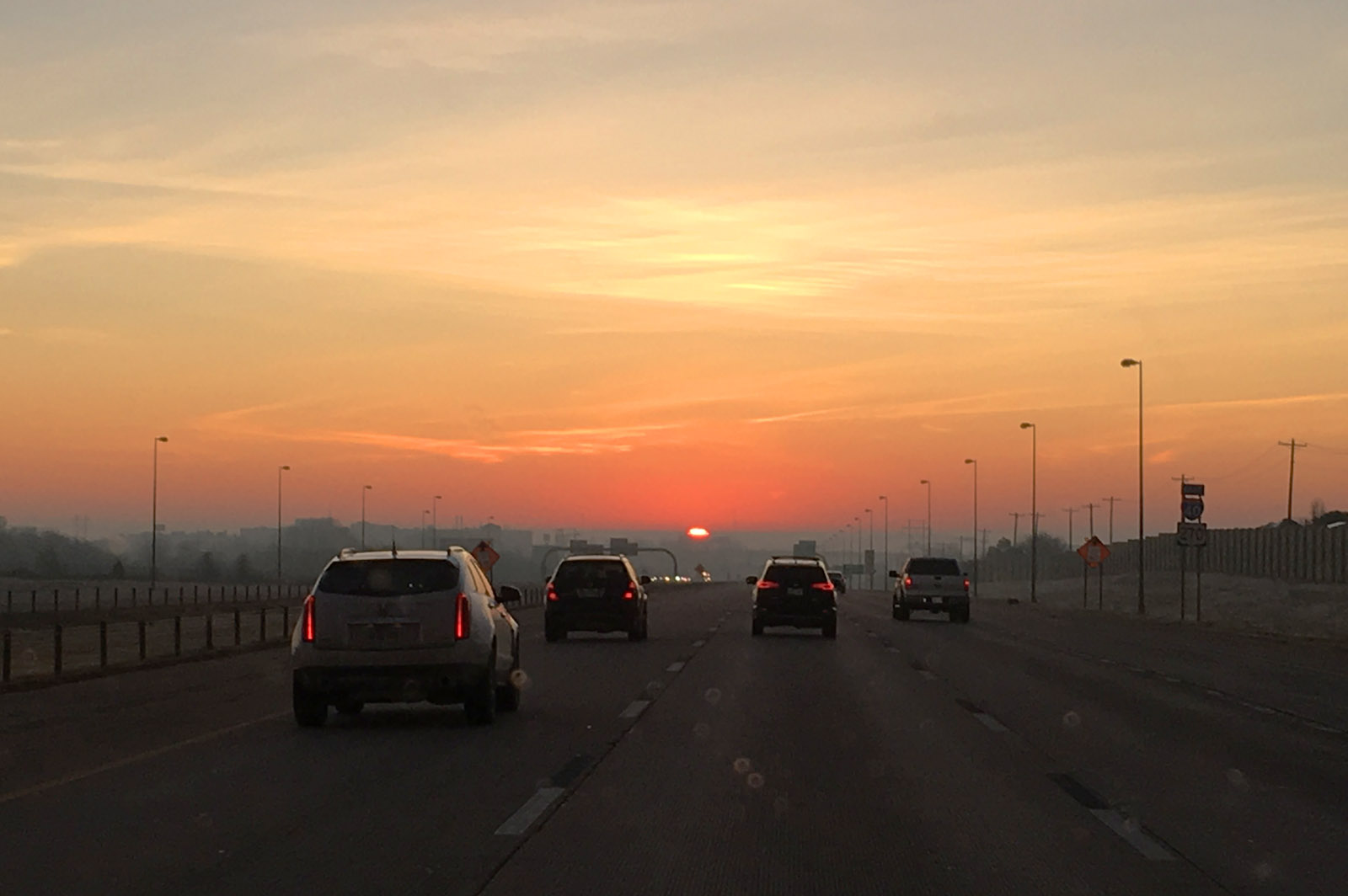
Sleeping well, I woke relatively early and packed well before sunrise, but paused for a pretty view of the waning crescent moon in the twilight sky over the frosty van after the chilly night. It was cool and humid enough there was considerable fog in the area. Eventually the sun rose up through the fog layer and made for a spectacular sunrise - right in my face, of course! But there were periods where the visibility dropped to almost zero in some locations, but eventually the rising sun burned it off...


The second day was mostly a blur. Moving diagonally across Oklahoma on I-44, then across Missouri towards St Louis. Stopped twice for gas and a time or two for bathroom and snack breaks. The only photogenic shots were approaching the Mississippi River bridge on the bypass around the south side of St Louis (have never tried going through that city). Being later in the day, 2 days before Christmas, traffic was already bad and I didn't want to risk trying to go through it this time! Along the bypass, there is always a good view of the distant skyline and the Gateway Arch. Have always wanted to visit it with Melinda, who grew up in the area and remembers it being built. Some day, but missed my chance to make the trip with her!

The trip across Illinois was uneventful - up I-55 to I-39 until we got closer to the Fox River Valley. Pulled into my Jewel store for some groceries about 7pm, which was just jammed with holiday shoppers, and pulled into the driveway about 8pm.  Wasn't long and the heat was on and the place was homey again... Hope you had/are having a great holiday season!

Friday, November 22, 2019

Look to the Skies!

It seems to have been a while since we've had a good planet grouping in the evening sky, but the current show is starting now! While Jupiter and Saturn have been in the evening sky for a few months, they are slowly retreating towards the Sun as the Earth's more rapid motion appears to move them to the far side of the solar system. Meanwhile, Venus has leapt from behind the sun (again, its motion is more rapid than the Earth), and is about to join the other pair in the early evening. Tonight Venus was still well below Jupiter, but tomorrow (Saturday, 23 November) will approach within 1.5 degrees (3 moon-diameters), making a striking sight! Next week, on Thanksgiving night, the crescent moon joins the grouping, and finally on 10 December, Venus passes Saturn and the conjunction show will end for now. Here is how they looked tonight (Friday, 22 November) from near Cornville, AZ. The planets are about to set behind the Mingus Mountains, with the lights of Cottonwood, AZ in the foreground. In the labeled image at right, you can also see the "teapot" asterism of Sagittarius as it also moves behind the sun for the season.

Catch the show while you can!

Thursday, November 14, 2019

The Window Seat!

It was a week ago now that I transitioned back to "Ketelsen West". The move was just in time evidently as the high temperatures back east are in the teens and single digits, and Tucson is warm (80s) and sunny. But I enjoy both locations, so pretty much am home at either location.

As always, I enjoy the plane ride and always book the window seat - looking down sun, of course! Having the sun shine into the window you are sitting creates bad reflections and makes for lousy photos. Always shooting down sun is the way to go. So for the morning flight, I was on the right side of the plane, scoping out the northern direction from our flight path.

We had full overcast, but not the predicted freezing rain as we took off. It made for a boring start to the flight other than what was seen as soon as we cleared the cloud deck - a glory! Now these are not unusual - I've even blogged about them a couple times before. In this last link, I even demonstrated that you can infer the cloud droplet diameters by measuring the diameter of the first ring of the glory. You can also tell from the centering of the rings that I was sitting at the rear of the plane. Everyone who looks has their own - the pilot in the front sees one centered on the front tip of the plane.

The clouds hung around thru all of Illinois, and it magically cleared showing the Mississippi and the "Quad Cities".  Shown at right, is the River, with Davenport above it, Bettendorf to the right, Rock Island in the middle of the River and Moline below. Below Moline is the regional airport I've flown out of a few times when visiting family back in the 90s.

The little game I play is to see how far I can keep track of our flight path. Of course, rarely we fly over my house or family farms I've spend my early years tending. When/if I get disoriented, take a photo of a distinctive landmark you can find on Google Maps and re-set the internal clock - even when after the flight! For a little ways we paralleled the Mississippi until it turned more south, and shortly after that I spotted the confluence of what must be the Iowa and Cedar Rivers in SE Iowa. I also had my IR camera at the ready which much more readily shows the streams and wetland areas as pure black at a much higher contrast. Here the color shot is at left and the infrared version (beyond our range of vision to the red at right. I purposely used the wider view for the IR since with its additional property of haze-cutting, it also shows details at greater distance too. In the color shot, you can spot the towns of Columbus Junction to the left of the confluence, and Fredonia to the right. Just above the confluence is a huge Tyson Foods processing plant...


Crossing southern Iowa wasn't particularly exciting - no major metropolitan areas. There are a couple big reservoirs which served as waypoints as we crossed hundreds of miles of farm land. The next BIG appearance was the Missouri River. The Missouri has seen some major flooding in recent years and I've not kept up with its current status. In the visible image at left, the main channel seems full and perhaps some nearby farmland appears flooded. What I noticed in taking the photo is there was a loop-de-loop in the center, and a cursory search revealed it to be an "oxbow" lake, where the meandering of the river got cut off, forming the characteristic shape lake. This particular one is called Big Lake Recreation area, about 25 miles northwest of St Joseph, Missouri. If it can be believed, the area looks even more impressive in the IR as shown at right. With the plethora of darkness, there might be much more flooding down along the Missouri that I first realized...


Once into the northern Kansas area, all bets were off as far as keeping track of the flight path.  At least off the right side of the plane, there were no metropolitan areas - only the occasional reservoir allowed checking the flight path later.

There is another interesting optical phenomenon seen when looking down sun. When very high (we were at 32,000 feet), where the plane's shadow would normally be, you see a subtle bright spot instead! Called the Opposition Effect, it is an enhanced brightness as there is a small area without shadows, and possible brightening depending on what type of surface it is. I was waiting for this brightening to pass over a town or urban area, and it finally did - over Lacrosse, KS. Shown at left, the diffuse bright spot is tough to pick out, but what it does do is make all the street signs glow brightly! You can see many of the signs along the main drags brightly colored as the glass balls built into the signs to enhance brightness at night also work to reflect the light back to the observer during the day (me, in this case, the shadow being cast on the town)...

At the western edge of Kansas, dropping into Colorado and New Mexico, the clouds increased and there was nothing more to see. I missed the normal sight of Albuquerque, the VLA Telescope, and Mount Graham as we approached Tucson - all lost in the clouds. It didn't really clear till we crossed the Rincons on the east side of Tucson. Circling the town once, to land towards the southeast, we flew pretty much right over my house, so got a good view of the Rillito Racetrack - a horse racing venue during late winter about a mile north of my house. Also seen on the image to the left is the bike paths that trace both sides of the Rillito wash where I bike all the time.

Continuing to circle, we had a view to the west also, where a distant view of Kitt Peak (the flat-topped mountain in the far distance) was seen over the nearby Tucson Mountains.

Another journey complete, but I'll guarantee you that next trip I'll be watching out the window yet again!

Wednesday, October 30, 2019

Colorful Coin

Under the category of "what the heck is that" is this coin I received in change the other day... The front side (left) is normal, but the back is in color! I didn't think much of it, figured someone was doodling with fingernail polish, and didn't think much of it. I finally dug it out of my change jar yesterday and took a good look at the obverse side. Shown at right, it appears someone took cares to color at least part of the design - trying to stay inside the lines, anyway... I took out my "supermacro" (Canon MP-E 65mm) to document here. The upper images here are at the lowest magnification I can get - about 1:1, or life-size on the sensor. The quarter just quite does not fit in the field of view. But even here you can see that the scene isn't a straight painting, rather it appears to be a multi-layer screen print. Note the screen dots on the details of the woman and what she is carrying - indicative of some sort of a screening or printing procedure.

I was not aware that this was a "thing", but a quick internet search showed them available at Amazon and Ebay for as little as $2 each when bought as a complete set. They appear to be legal tender, which is likely how I received it, when someone needed a quarter and spent this for whatever purchase was needed...

The close-ups here were taken with the same lens at about 3X magnification (scale at bottom is in millimeters. Note especially on the "Pennsylvania" detail, there appears to be a slight registration error of about a half millimeter. At right you can also see the barely-visible E Pluribus Unum through the layer of color at bottom...

All-in-all, an interesting circumstance to run into this item. They do not appear to be common, as after posting last night on FB, most have indicated they've never seen one! One fellow knew someone that collected them, but were new to another half dozen commenters. But they are out there and another reason to pay attention to your money!

Wednesday, October 23, 2019

The Window Seat!

Sorry I've been missing... I don't intend to go 3 weeks between blog posts, just a lot less inspired these days than I used to... Always intend to do better - I've got 3 or 4 I WANT to write, just seems something more important comes up, even if it is sitting watching a movie on TV!

I've been at "Ketelsen East" for weeks now, and the trip up was quite spectacular! Perfect weather for the first half of the trip, and I took nearly 200 frames on the flight. Of course, a lot of those were for stereo pairs, so sometimes took 2 or 3 as we flew along for a good baseline for clouds or features on the ground.


The flight was delayed - the plane came in late. The Chicago noon flight originates there in Illinois, then returns on the flight I take. Once we took off (about 20 minutes late) I could tell the pilot was intending to make up time as he turned northeast immediately! Usually we take off towards the SE and sometimes go 80 miles or more before heading towards the NE, but even shortly after takeoff we flew over the "Boneyard" of the Davis Monthan Air Force Base. The Aerospace Maintenance and Regeneration Group (AMARG) stores over 4,000 planes for long-term storage for possible return to service or for use in parts for planes in use. At left is one view of part of the storage facility, and at right, a second frame is added from a couple seconds later to make an anaglyph stereo pair (red/blue glasses needed to see the 3D!). For reference, I've never flown over it before - my first indication that we had started our northward journey early!


I usually book the left-side window so that I'm not looking or shooting into the sun. That means going towards Chicago Mount Graham and the LBT telescope are some distance out my window. We've been as far as south of Willcox, so it can be as far as 20 miles or more away. I was suspicious when I couldn't spot it and suddenly it appeared almost straight down below me! I could barely catch it without the observatory partially blocked by my window frame! Shown at left is a wide shot of the 3 telescopes atop the mountain. The mountain road up from near Safford (east side of the mountain) winds west past the Observatory, then snakes up the slope from the west as shown here. Then at right is shown the stereo anaglyph that reveals the telescopes "popping out" from the peak, and the local terrain as well as the winding road climbing the hill.


Shown here is a close-up of the Mount Graham International Observatory (MGIO) which consists of the Large Binocular Telescope (LBT) in the large rectangular structure, the Vatican Advanced Technology Telescope (VATT) at left, and the Sub-Millimeter Radio Telescope (SMT) between them. Interestingly, I did a substantial amount of work on all three of the telescopes! Also recently in the news, the SMT was recently one of the telescopes that added data to image the black hole in the galaxy Messier 87! And of course, another 3D image as above, starting to show some of the topography of the east side of the mountain as well...

I think this is about the first time I've been able to get a good look at the mountaintop since the big fires there a couple years ago. It looks to have pretty much decimated the stands of trees atop Graham other than the well-defended area around the observatory. Go to the link to see the amazing footage of a DC-10 dropping retardant on the fire which all but saved the Observatory!


Another 30 miles past the Observatory is another feature usually seen some distance away - the largest open-pit copper mine in the western hemisphere - 740 million pounds was refined in 2017, and employed over 3,000 people! This time, again we flew pretty much right over it, and a pair of frames a few seconds apart show good stereo results, as shown in the image at right...

According to references in Wikipedia, it has ore reserves of 3.2 billion tons grading at about .2%, so 500 pounds of ore must be processed to return a pound of pure copper! From an industry paper describing the operation, it is the largest application of leaching/solvent extraction operations in the world. The leaching fields are not well shown in these images (out of frame to lower left), but the pits are shown well and give a great 3D effect in the anaglyph at right...


Shortly after the mine, I got lost... We typically pass over the VLA radio telescope array in west-central New Mexico, but I never saw it - likely off the right side of the plane. Also never seen was Albuquerque - another waypoint I usually always spot. Another indication that we were north of the usual path taken. What I did spot was some interesting terrain NE of the Morenci mine - likely in the Gila Wilderness in New Mexico. There are some striking canyons seen before there, and while these weren't exactly the same landforms, that's what I'm calling them! They make an interesting 3D view at left...

When lost, you look for something striking to try to identify from Google Maps. After not seeing Albuquerque, I spotted some contrasting dark and light landforms. A quick look online found it - the towns of Milan and Grants in north-Central New Mexico, shown at right.


A few minutes later another interesting shot - northern New Mexico, like the area around Flagstaff in northern Arizona, is full of volcanic features. We passed over a distinctive peak that otherwise defied description. I think it is Cerro Alesna. It is described as a "volcanic neck", which I believe is the remnants of a lava plug in the volcano, then the volcano eroded away, leaving the remarkable outline. Baboquivari south of Kitt Peak where I've spend many hours gazing, is a similar form and also quite striking. The peak part here is so dark it is difficult to see details in the 3D image, but you get the idea... Straight shot at left, 3D at right...


I got lost again - easy to do in southern Colorado with the southern Rocky Mountains... Again, was looking for something striking to find on a map and once clear of the mountains, found this colorful set of catchment ponds at the south end of a city on the eastern edge of the mountains. Yes, it was Colorado Springs, and the catchment ponds (bright yellow, orange and white) are associate with the Nixon coal-fired power plant near the small town Fountain. On the upper left of the frame at left, which is the bottom of the next frame at right is the landing strip for the Butts Army Air Field serving Fort Carson in Colorado Springs, which is the metropolitan area snuggled up against the Rockies in the photo at right...


Colorado is a big, mostly featureless state - at least the eastern half. So I got lost again. I saw a huge windmill farm that seemed to go on for many miles (and minutes of flying time at 500mph!), but windmill turbines are difficult to locate on Google maps, especially if they are new and maps are not! It wasn't until another 20 minutes till I saw another positive landmark, easy to spot on the Google maps - a big reservoir! A long straight one, then followed by another a few minutes later. Couldn't find anything in Kansas (the usual route), but finally found them. At left is Swanson Lake near Trenton in southwestern Nebraska, and at right, the distinctive shape is of Red Willow Reservoir.


As can be seen in these photos, even over the few minutes between these last photos, clouds were increasing, and they became quite thick - I never saw the Missouri or Mississippi Rivers, but clouds are fun to watch too - especially in 3D!


These photos were taken in southern Colorado, with the front range coming into view. At left is a single photo - one of the few showing the sky. Note how dark blue it is when flying close to 40,000 feet - not much scattering to make it the normal sky-blue we see from the ground! And while the horizon looks curved, I'm not certain I should point it out as lens distortions, especially at wide angles, can cause that too! At right is the 3D anaglyph version. I wasn't sure that the wing, obviously not displaying ANY baseline 3D, would screw up the image, but it is obvious that it does not.


Photos of clouds are oftentimes confusing, as you lose perspective when they can appear at several levels and is difficult to interpret if a piece here is in front or back of others. The 3D versions are MUCH more definitive, and works on even the messiest of photos - in stereo it is usually easy to see the shape and relative distance to the clouds. Here are a couple more interesting structures I shot once the skies clouded up over the Midwest and there was nothing else to see till we landed in a misty rain in Chicago.


So you will have to forgive my weakness for 3D images - or at least trying to capture them! Seems the anaglyph version of display is easiest for people to view (many have the required red/blue glasses. Of course, it can mess up the color balance of objects that are colored similarly to the red or blue colors of the filters needed to view the images. At least I have fun - up to YOU if you enjoy them too!

Tuesday, October 1, 2019

Three Years!

I had known it was coming, but wasn't sure to dread or look forward to the third anniversary of Melinda's passing this last 22 September. I decided to embrace it, and when a friend told me she had business in Puerto Peñasco, the die was cast! Melinda and I had travelled many times to the little port an hour south of the SW Arizona border, so invited myself along and retraced some of our steps there! PP has the closest beaches to Tucson, and the port on the Sea of Cortez is best known for its prized shrimp. Most of our trips down across the border were to visit our friend Margie, who spends much of the winter there, but have also made other trips with friends, so drew from that trip too. Shown here are a trio of my favorite photos of her there.

At left is an early photo, taken the day before my birthday (December 15, 2006), just a few months after we started dating. It is a spectacular photo - some thought it was taken in front of a mural, but is actually a live sunset from the patio of a favorite restaurant "Casa del Capitan" atop a large hill next to a lighthouse overlooking the port. It is often windy out there but this evening it was calm and spectacular not only watching the sun set, but seeing the stars come out as the evening progressed - a memorable evening indeed!

Fast forward 5 years and a few months, and we were down again with her good friend Carolyn. Margie wasn't available this trip, so Melinda found a 2 bedroom condo rental for a long weekend that was less expensive than a hotel at the still-under-construction Esmeralda. We only saw one other room in the huge building that was occupied, even though it was near the peak of the influx of tourists (4 March, 2012). At right is a photo of her relaxing on our 7th floor balcony overlooking the Sea of Cortez towards the west.

Finally a year and a half later we returned for the Christmas holiday (23 December, 2013) at Margie's. She has a beautiful place there, including this outside eating location when the weather is good (most of the time!). Margie has it strung with Christmas lights and the view of the post-sunset sky and scattering of colored lights was too magical to pass up! This was taken 5 months into the start of her cancer treatments, but the Melinda smile is still bright!


This trip I insisted on dinner atop the lighthouse hill where the top photo was taken. It was a nice evening - storms to the east, but a nice sunset. Dinner was at Pane e Vino Ristotante, adjacent to Captain's, a pizza place below and upscale Italian above. There was an excellent view of the sunset and port below from the high perch I'm guessing a couple hundred feet above the Sea of Cortez. The sunset shots here are handheld with a 200mm lens. It seems to set so quickly over the water. Distant mountaintops from Baja can be seen to the nearly due west, since this was taken nearly on the Autumnal equinox... When you click and enlarge them, I love the "crepuscular rays" emanating upwards from cloud structure or mountains, even after the sun had set from my location...


The natural lights of twilight faded quickly and the lights of Puerto Peñasco came up at the same time. Back to the kit zoom lens, the wide shot here is a 3-frame HDR, a combination of 3 frames of different exposures to record more light levels. At lower left is "the Malacon", the commercial center of Puerto Peñasco, including restaurants, fish and shrimp mongers, dentists, pharmacies and tourist trinkets - most anything you want in an over-the-border destination! Across the bay are the high rises and condos of "Sandy Beach, and the body of water leads to the right to the port where hundreds of shrimping boats are docked before heading out. You can see why we have loved the view from there when weather conditions allow a meal out there!

So it was a nice trip - not particularly emotional for me, though shed a few tears when I re-read my blog entries of her last days 3 years before - the first I've reviewed them since putting down those thoughts... Melinda will always be a part of me, our decade together among my happiest. I know all of you who knew her also have a special place in your heart for her.